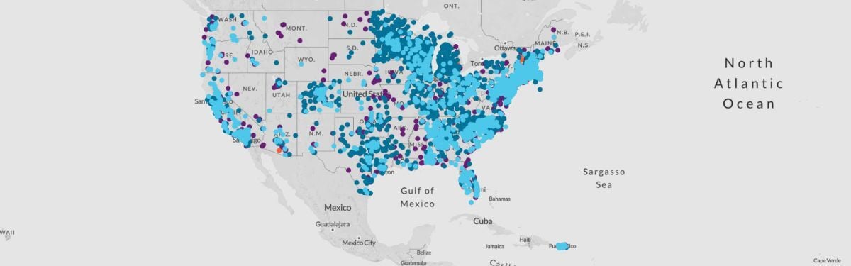
Mapping the PFAS contamination crisis: New data show 7,457 sites with PFAS in 50 states, the District of Columbia and four territories
Update: August 9, 2024: The Environmental Protection Agency has released the fifth round of public water system quarterly testing data for the toxic fluorinated “forever chemicals” known as PFAS, as required by its Fifth Unregulated Contaminant Monitoring Rule, or UCMR-5. The UCMR-5 data reveal 2,067 sites have detectable levels of PFAS, based on test results from approximately two-thirds of the community water systems that will be tested under the rule. The new data, along with reporting from states and other sources, confirm 130 million people in communities throughout the U.S. have drinking water that has tested positive for PFAS. A 2020 study published by EWG scientists estimated more than 200 million Americans are served by water systems with PFOA or PFOS in their drinking water at a concentration of 1 ppt or higher. The UCMR-5 requires reporting only of detections at 4 ppt or higher for these chemicals. The results, which build on EWG’s landmark PFAS contamination map, highlight the sheer scale of the PFAS problem in the U.S.
WHY IS THIS MAP IMPORTANT?
The number of U.S. communities confirmed to be contaminated with the highly toxic fluorinated compounds known as PFAS continues to grow at an alarming rate.
The latest update of this interactive map shows PFAS pollution in public and private water systems. Details about our sources and methodology are here.
Explore the map

WHAT IS THE GOVERNMENT DOING?
The Environmental Protection Agency has known about PFAS health hazards for decades but until recently failed to limit PFAS in drinking water or set cleanup standards.
The Biden-Harris administration has delivered on several key promises to tackle PFAS contamination by regulating the chemicals in drinking water, designating PFAS as hazardous substances under the federal Superfund law, ending government purchases of some products containing PFAS, and funding additional research into the chemicals.
In April 2024, the EPA announced new standards for regulating six PFAS in drinking water. The new rule requires public water systems to complete initial monitoring for PFAS by 2027. Water systems have until 2029 to comply with new, stringent levels of PFAS allowed in drinking water.
The EPA has added 196 PFAS to the Toxics Release Inventory, or TRI, in response to a congressional mandate. A listing in the TRI requires facilities to report releases of those PFAS into the environment. The EPA in October 2023 closed a loophole in TRI reporting that had allowed many manufacturers to evade reporting requirements.
The agency in April 2024 designated PFOA and PFOS as hazardous substances under the Superfund law. The designation will jumpstart PFAS cleanups and help the EPA hold polluters accountable.
The Department of Defense has tested for PFAS at military installations but made little to no progress cleaning up contamination, and drinking water remains threatened.
A number of states are also taking steps to address PFAS pollution by banning some uses of the substances and setting cleanup standards.
–
The Environmental Working Group welcomes requests to reproduce EWG PFAS data for peer-reviewed articles in scientific journals. To request permission, please email a completed EWG Materials Request Form to [email protected]. EWG reviews requests on a case-by-case basis and reserves the right to deny permission for any reason, at its sole discretion.
About the Map
For all water systems with a detection of PFOS, PFOA or another PFAS, a maximum concentration for each PFAS and a maximum total PFAS concentration is displayed. The maximum levels listed are from a single point in time and do not reflect whether a water system has changed sources or is treating the water to reduce PFAS levels.
All locations represented on the map are approximate and intended to portray the general area of a contamination site or a community water system. Locations were mapped using the best data available from official records, including data provided by tests of public drinking water systems, the Unregulated Contaminant Monitoring Rule, the Safe Drinking Water Information System, the Department of Defense report “Addressing Perfluorooctane Sulfonate (PFOS) and Perfluorooctanoic Acid (PFOA),” among others.
Levels listed are for the range of the total of all PFAS detected at the time of the tests and do not reflect whether a water system is treating the water to reduce levels.
Data on contaminated water system, industrial and military sites was current as of August 2024.
Disclaimer: EWG has worked to ensure the accuracy of the information provided in this map. The map is dynamic. This contaminant site, results, suspected sources and other information in the database may change based on evolving science, new information or other factors. Please be advised that this information frequently relies on data obtained from many sources, and accordingly, EWG cannot guarantee the accuracy of the information provided or any analysis based thereon.